Picture this: you ease off your lift, idle past swaying palms, and point the bow toward Hillsboro Inlet. In Lighthouse Point, that vision is everyday life for many boat owners. If you are comparing canals, bridge timing, depth, or boat size, a little local knowledge saves you time and stress. In this guide, you will learn how Lighthouse Point’s canal types match different boating lifestyles, how to estimate run times to the ocean, and what to verify before you buy. Let’s dive in.
Why Lighthouse Point works for boaters
Most residential canals in Lighthouse Point connect to the Intracoastal Waterway, which leads quickly to Hillsboro Inlet to the northeast and Port Everglades to the south. The inlet is close by. Using public coordinates, the straight-line distance from the city center to the Hillsboro Inlet light is about 1.05 nautical miles. You can confirm routes and aids to navigation on the official NOAA chart coverage for this coastline using a trusted chart viewer like the NOAA chart library.
Why this matters: short Intracoastal hops mean you can reach offshore grounds fast, especially if you live east of US 1. Many properties market “minutes to Hillsboro Inlet,” which is realistic if your dock sits on a wide basin with direct access. The exact time depends on speed limits, bridge openings, and your specific canal exit.
Canal types and the lifestyles they serve
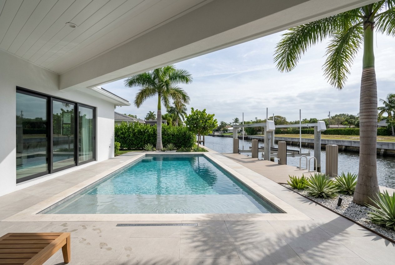
Wide, direct-access basins
If you own or plan to own a larger sportfisher or convertible, look for wide canals with generous frontage and no fixed bridge on the immediate route. In areas like Venetian Isles, listings often reference canal widths around 80 to 120 feet or more and highlight ocean access. These basins typically offer easier turns, longer usable dock faces, and comfortable maneuvering for 40 to 70 foot vessels. Always verify width and depth at the exact dock, but these neighborhoods are popular with serious anglers for a reason.
Narrow residential canals and finger piers
Interior canals can be narrower with limited turning basins. These streets work well for smaller center consoles, runabouts, and trailerable boats. You will want to be conservative on length overall and beam, and plan for careful docking in tight quarters. The upside is value and a quieter residential feel. The tradeoff is less room for very wide or very long boats.
Club and community marinas
Prefer full-service convenience or own a boat too large for your private dock? A club or nearby marina can solve for depth, turning room, and services like fuel, pump-out, and maintenance. Facilities near Lighthouse Point commonly advertise quick runs to the inlet. As one local option, Hidden Harbour Marina in Pompano offers convenient access to Hillsboro Inlet and managed slips.
Bridges, depth, and channel notes
Your quickest ocean approach is via the Intracoastal to Hillsboro Inlet. For official navigation notes, soundings, and controlling depths, consult the U.S. Coast Pilot along with NOAA charts. The Coast Pilot explains that while channels are managed, depths change over time and local basins are not uniformly dredged. You can browse a public excerpt of Coast Pilot 4 to understand how the federal waterway is maintained and described (U.S. Coast Pilot excerpt).
Bridge openings matter, especially if you cruise north or south along the Intracoastal or carry a tall mast. Federal rules set opening times and restrictions for area drawbridges, including the SR A1A bridge at the inlet. Review the current schedules in the U.S. Coast Guard drawbridge regulations so you can plan your run and avoid long waits (33 CFR drawbridge rules).
Depth at your dock is not guaranteed by neighborhood reputation alone. Private canals vary and may have shoaling. The smart move is to request a recent depth sounding at mean lower low water, verify any prior dredging, and confirm lift dimensions if you plan to store the boat out of the water.
How long to the ocean?
A simple estimate helps you compare locations: time in hours equals distance in nautical miles divided by speed in knots. The straight-line distance from central Lighthouse Point to the inlet light is about 1.05 nautical miles, which is under 10 minutes at 8 knots and roughly 12 to 15 minutes at common no-wake speeds. Real routes add time because you will follow canals, abide by posted speed limits, and may wait for a bridge. You can view the inlet’s position on public map references such as Mapcarta’s Hillsboro Inlet Light page.
Typical ranges by location:
- East-of-US 1 canals and wide basins: about 5 to 15 minutes to Hillsboro Inlet under routine conditions.
- Farther west or indirect routes: about 15 to 30 minutes or more, depending on slow zones, routing, and drawbridge timing.
How to refine your estimate:
- Measure your routed distance from dock to inlet on a chart or mapping tool.
- Apply realistic speeds: 5 to 6 knots in no-wake zones, slightly higher where posted.
- Add expected drawbridge wait time if you need an opening. Federal rules provide scheduled windows.
- Add a buffer for weekend congestion and tide.
Will your boat fit?
Before you assume a boat will fit, confirm these details at the specific property.
Quick fit checklist
- Usable dock length. Measure the actual tie-up face. Finger piers and pilings reduce space. Compare to your vessel’s length overall, including platforms and bow sprits.
- Beam and berth width. Check the distance between piles or dock faces. Leave 1 to 2 feet for fenders. Wide-beam boats or catamarans need more margin and turning room.
- Draft and depth. Request a recent depth sounding at the dock and along the canal to the Intracoastal. Aim for 1 to 2 feet of under-keel clearance at the lowest routine tides.
- Turning room. Narrow canals and small basins can make backing and pivoting challenging for large boats. Walk the basin and visualize the turn with wind and current.
- Lifts and tie-downs. Confirm lift capacity and height. The City requires permits for docks, lifts, and re-decking. You can review local guidance on the City of Lighthouse Point’s permit FAQ.
Permits, seawalls, and dredging
Marine work involves local, state, and often federal oversight. In Lighthouse Point, the City permits docks, lifts, and related marine structures. Some projects require state review before the City issues a permit. Always request a property’s permit history, seawall reports, and as-built drawings from the seller or the City (City permit FAQ).
Dredging is possible but technical. Projects typically require state Environmental Resource Permits and may also require authorization from the U.S. Army Corps of Engineers. The Corps maintains public notices and records you can search to verify prior dredging and any conditions (USACE public notices example). For background on marina siting, environmental protections, and maintenance best practices, the EPA’s Coastal Marinas handbook is a helpful primer (EPA marina guidance).
Bottom line: an unpermitted dock, a failing seawall, or undocumented dredging can delay closing and add cost. Bring these items into view early so you can negotiate with clarity.
Choose your boater profile
Weekend angler and dayboater
If you love quick morning runs to reefs and wrecks, look east for shorter legs to the inlet. A smaller center console on a lift works well on many interior canals. You will trade a little turning space for value and still enjoy an easy hop to Hillsboro Inlet with good planning.
Serious sportfisher owner
If you run a 45 to 70 foot sportfisher and troll offshore often, prioritize wide canals with generous frontage or a managed marina slip. You will appreciate larger turning basins, longer dock faces, and straightforward access to the Intracoastal. Club options can round out your plan for guest dockage, service, and fuel.
Occasional cruiser and club moorer
If you prefer a lock-and-go setup or own a boat that outgrows your backyard, a club or local marina is the simplest path. You still get fast runs to the inlet without managing a complex private dock build. Consider Hidden Harbour Marina and other nearby facilities for slip availability and services.
Smart buyer checklist
Use this quick list as you evaluate properties and plan your boating routine:
- Verify route to the inlet on official charts. Check depths, aids, and landmarks on the NOAA chart library.
- Confirm drawbridge schedules for your route using the 33 CFR drawbridge rules.
- Request a recent dock and canal depth sounding at mean lower low water, plus any dredging records.
- Review dock, lift, and seawall permits with the City’s permit FAQ.
- Search for prior dredging or in-water work through USACE public notices.
- Consult the U.S. Coast Pilot excerpt for navigation context along this stretch of the Intracoastal.
Next steps
If Lighthouse Point is calling your name, align the canal, dock, and route with how you actually boat. With the right match, your home doubles as your launch ramp and your weekends get a lot more fun. For tailored property shortlists, off-market options, and a smooth waterfront purchase, connect with Megan Romine. We will help you verify the details, from permitting to depth, so you buy with confidence.
FAQs
How close is Lighthouse Point to Hillsboro Inlet for boaters?
- The straight-line distance from the city center to the Hillsboro Inlet light is about 1.05 nautical miles. Real-world runs vary with canal routing, speed limits, and bridge timing. See the inlet’s location on Mapcarta.
Where can I find official charts for Lighthouse Point canals and the inlet?
- Review NOAA coverage using a trusted viewer like the NOAA chart library and pair it with the U.S. Coast Pilot excerpt for navigation notes.
Do drawbridge schedules affect my run to the ocean?
- Yes. Federal rules govern opening times on the Intracoastal, including the SR A1A bridge at Hillsboro Inlet. Check the 33 CFR drawbridge rules and build wait time into your plan.
How do I estimate run time from my dock to the inlet?
- Use time in hours equals distance in nautical miles divided by speed in knots. Apply posted speeds for no-wake zones and add time for routing and any drawbridge waits.
Will my 50-foot sportfisher fit at a Lighthouse Point dock?
- It depends on usable dock length, berth width, depth at mean lower low water, turning room, and lift capacity. Verify measurements, recent soundings, and permit history before you commit.
What permits do I need for a new dock or boat lift in Lighthouse Point?
- The City permits docks, lifts, and related marine work, and some projects require state review first. Start with the City’s permit FAQ and consult your contractor and closing team.
Is dredging allowed if my canal is too shallow?
- Dredging can be permitted but involves state and often federal approvals, testing, and conditions. Search prior records through USACE public notices and discuss requirements with your marine engineer. For context, see the EPA marina guidance.